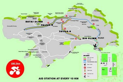
"Once they are out of the water, the athletes run up a short distance from jetty to T1, grab their bikes, and get started on the three-loop bike course. The cyclist after Seaview Hotel will make a right turn at the traffic light and will take a left turn on LISRAM highway. The profile of this highway has an incline of 10 degrees for about 100 meters up and downhill. Once upon reaching the end of this highway cyclist have to take a left turn and will make a U-turn after the Langkawi Technical School
The "loops" are actually out and back along this stretches that take the athletes from here to the other side after Datai junction at KM 13 they turn around and come back on this stretch, which they make 3 loops and on the final loop athletes will take Ayer Hangat road after the roundabout back to finish the bike course."
Hmmmmmmm....good news I guess. I will get to climb the "LISRAM Highway"(marked as Big Climb on the map) only once. And most importantly with fresh legs as it will only be about 3-4km into the bike leg. I remember this hill to look like a wall from far, especially so after 90km on the saddle back in IM2004. Datai Climb will again not be featured and that's good news too.
Looks like I will be doing the 3 loops away from Seaview Hotel. Have not ridden along Stretch A. Remember big part of Stretch B to be rolling hills.
2 comments:
hi chee. Saw u while I cycled in Putrajaya last month with Fook.
All the best for IM. Take care
I previewed stretch A last weekend while up there kayaking. It seemed to have a 2-3km uphill going past the Jalan Gunung Raya road. My reading is that Stretch A will be covered more than once. So it should be a hilly course. Also the u-turn at the far end of Stretch B, maybe moved farther out, where there is a couple hills. S
Post a Comment